:: home
:: books
:: gallery
:: data
:: blog
:: kids
:: shop
:: bio
:: help
:: contact
:: ChrisKridler.com


Words/images COPYRIGHT © 2021 by Chris Kridler. All rights reserved. Do not use Sky Diary photos on other Web sites. Personal use as computer wallpaper is permitted, but do not distribute photos. Write for information about purchasing video, photographs or articles. | Frequently asked questions
|
|
dispatches: September 2008
back | archive | current
28 SEPTEMBER 2008
After the rush: Hurricane season is far from over, but it was stunning how quickly that last wave of violent storms turned to relative calm. Of course, Tropical Storm Kyle is steaming into the northern climes right now, and there are more possibilities brewing, but I think most normal people were glad for a break after Ike ripped into Galveston and Houston. Knowing the tragic history of Galveston and the 1900 hurricane, it astounded me that some people didn't evacuate. I've been there, and it was a handsome little town, full of historic buildings. I hope it can recover. In the meantime, I've created a Hurricane Ike ornament, now available in the Storm Stuff Store. I've found even when the memories are difficult, people want to commemorate such a significant event.
Meanwhile... I'm joining several other artists on Wednesday, Oct. 1, from 3 to 8 p.m. at Juice N Java Cafe in old downtown Cocoa Beach (75 N. Orlando Ave. (southbound A1A)). I'll be showing and selling my storm photography, along with a few of my orchid pots (including one that looks like a tornado!). There will be tapas, beverages and a fun night out. Come on down.
1 SEPTEMBER 2008
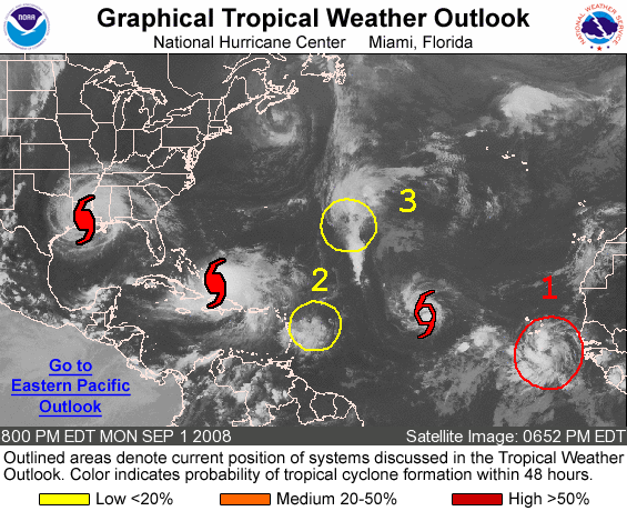
The Sept. 1 tropical weather outlook does not give those of us in Florida the warm fuzzies. Click on the image for the latest version on the National Hurricane Center site.
|
It can only get worse: While the Gulf Coast is suffering from Gustav, those of us who have already had our 20 to 30 inches of rain here in Brevard County, Florida, thanks to Fay are not real thrilled with the Atlantic right now. Hurricane Hanna, Tropical Storm (soon to be hurricane) Ike, the future Josephine and other cranky hot spots are all lined up. It's like a mux of 2004-2005. I kind of like outer bands, with their occasional thrills and fast-moving clouds. But this hurricane onslaught stinks, and the current pattern is going to keep forcing them into land until Africa runs out of tropical waves. As a storm chaser, I still fail to get excited about experiencing hurricanes, especially when they might hit our house. I find them fascinating, but the best view has to be from the International Space Station. Get the latest model forecasts and other outlooks in my tropical data links.
|