
:: books
:: gallery
:: data
:: blog
:: kids
:: shop
:: bio
:: help
:: contact
:: ChrisKridler.com


|
Words/images COPYRIGHT © 2021 by Chris Kridler. All rights reserved. Do not use Sky Diary photos on other Web sites. Personal use as computer wallpaper is permitted, but do not distribute photos. Write for information about purchasing video, photographs or articles. | Frequently asked questions |
storm gallery: chase diary 2001
Here's a collection of bulletins from the field, written during my 2001 storm-chasing trip in the Great Plains. They are slightly edited. Dates reflect when each bulletin was written.
May 7: Norman, Oklahoma
Have I been in the Plains only one day? Yep. Or a day and a half. I left the Melbourne, Florida, area Saturday morning and was chasing in Oklahoma and Texas on Sunday afternoon. Having to traverse such a distance made it hard to get to the action in time ... storms fired early, and I missed the tornadoes, which all happened right after the storms initiated. At least they blew in my target area. I was thinking, "I'm not a meteorologist, but I did stay at a Holiday Inn Express last night."
I checked data at a truck stop in Paris, Texas, then headed north and west. (Thanks to Jay Antle and Steve Sponsler for more info on the way.) At one point I was east of Ardmore, Oklahoma, blasting west to try to catch a warned storm. Its brilliant white anvil cut into the blue sky like a round, hard disk, and its updraft was crisp. It looked powerful and nasty. It was a shock to the system. I hadn't seen the like in a year! Florida storms simply aren't that brutish, most of the time.
As I got close to it, it was clear it was not as organized as I had hoped. It was already starting to fall apart. Beneath its black and roiling underbelly, I came across what in a more organized storm might have been a classic wall cloud - the lowered area where you might look for a tornado. But it wasn't rotating, really, just roiling. Nonetheless, it made me nervous, since it was practically over my head, so I circumnavigated the area. I ended up in the town of Kingston. A bunch of locals - storm spotters and spectators - and some chasers were wandering around too. I've never seen so much random motion in the sky, and there were areas where chunks of scud clouds were forming and lifting in the storm. Sometimes such motion is a clue that a tornado could be trying to form, but I just didn't believe it, given the disorganized state of the storm. Yet I watched with interest, as you might imagine, and jumped when the town's tornado sirens suddenly launched into their slowly climbing, morose wail. Tornado?! Nope. Just a mess.
I wandered around some more and saw great shafts of sunlight punching through a vast silver cloud deck like the golden fingers of the gods. Very pretty. Not very violent. Darn.
I ran into some old pals from the Cloud 9 Tours group in Kingston again, then eventually ended up over the Red River and among more severe storms in north Texas, where I shot some lightning photos. Then I headed "home," to Norman, Okla., where I was to meet up with chase partner Dave Lewison.
Today has been relatively relaxed. I spent several hours at the Storm Prediction Center here, checking out the processes, procedures and people for my Florida Today weblog, which is more newspaperish than these bulletins. I also ran errands and bought the Orbital CD recommended by Cheryl Chang and Steve Sponsler, who are back home in Florida - very cool chase music.
Tomorrow, it looks like we'll head up into north-central Kansas to get into position for iffy possibilities on Wednesday. That could change in the morning. It's hard to know what's going to happen, and the weather pattern is really not terribly favorable for severe weather right now. Sigh.
May 11: Oklahoma City
I'm not really in Oklahoma City for storms. I'm here because it's a good place to end up, the crossroads of the Plains. It's also a little closer to the storm chaser picnic that's supposed to happen Sunday in Texas, and I'll probably end up going there with the folks I'm currently hanging out with: chasers Dave Lewison, George Kourounis and Mark Robinson. George and Mark have come all the way to the Plains from Ontario.
The past few days have been pleasant but not earth-shattering. The tornadic storms have been just about unreachable. On Tuesday, May 8, Dave and I were heading north to Nebraska to get into position for Wednesday when a few wisps of white appeared in the blue sky in northern Kansas. It looked like storm anvils, but we could hardly believe it, given that nothing was supposed to happen at all on Tuesday. We decided to check them out. 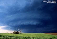 One of them looked particularly interesting as it developed a base and even a wall cloud in short order as we approached. A severe thunderstorm warning was issued on the storm, which evolved into an elegant, rounded "mothership"-type storm. The shape indicated rotation, but the motion seemed subtle. However, it was enough to set off tornado warnings, and though storm spotters reported tornadoes, we never saw anything of the kind despite having a good view of the storm. One police officer told another chaser he was in the area of a reported tornado and didn't see anything, so we don't know if the tornadoes were phantoms or not.
We followed the storm for some time, at one point trying to take a shortcut on a farm road and finding the surface mud as slick as ice. We quickly turned around and fishtailed our way out of there, with soft hail splattering on the windshield as we went. When the storm turned to mush, we resumed our trek north and found another one that also had an intriguing base. It was getting dark, however, and twilight can play tricks on the eyes, making a few wisps of cloud look like an attempt at rotation or something more. We gave up soon enough and headed north to York, Nebraska, for the night.
The next day, May 9, the best area for storms seemed to be western Iowa or southwestern Minnesota. The best wind profile was certainly in Minnesota, and we tried to get as far north as we could, but we simply couldn't reach the tornadic storm, even though we liked the looks of it. We settled for a pretty, high-based one in southwestern Minnesota that produced a definite swirl for a few minutes, but it was obviously insincere. No tornado. It took forever for the storm to develop the low base that showed it meant business, but despite a period when it was sucking in inflow air, it just couldn't get its act together. Another storm, with cascading shafts of rain and hail glowing orange with the sunset, collided with that one.
We'd found George and Mark during the chase, and we all spent the night in Des Moines. We certainly didn't spot the tornadic potential in eastern Iowa the next day, May 10 - not many did, so few people saw the tornadoes there - so we headed for southwest Iowa. After a while kicking around a truck stop, chatting with other chasers and checking data on the Internet, we liked the looks of northwest Missouri and headed there. Suspense was high, as the cap - the warm layer of air well above the surface - refused to break. We looked at tiny, puffy clouds under a blue sky and waited.
Then - a turkey tower, a skinny (and, frankly, phallic) cloud tower, shot upward. Back to our west, we saw other towers breaking the cap. After some pondering, we decided to go after the storm that had formed near us, as clouds started building into it. We drove to the top of a hill on a tiny side road to take a look. Soon the storm was an explosive convective bomb, growing with hard-edged, crisp, cauliflower blooms, its expansion easily visible to the naked eye. We scrambled east, lurching up and down on precipitously steep hills, with Dave uttering the occasional groan as his stomach flopped while I drove. Yet we all soon stopped our pursuit, because our fantastic bomb had almost no base. It was a dud. And behind us, the line of storms had become severe. A look at radar on Dave's tiny TV showed that our storm was weak, and though it had begun to suck in some low-level moisture, it was doomed.
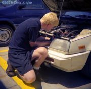
We ended up going west and punching into the wind, rain, lightning and hail in the line. We didn't get monster hail, but we did get quite a hurricane blow when we stopped under a gas-station overhang for shelter in hopes of sampling large hail from a position of safety. The winds were intense and were blowing the rain and small hail almost horizontally. After a Pizza Hut dinner in Maryville, Missouri, it was east into Kansas - a late-night drive to get into position for today. And today, well, not much interesting happened, though even now there are some severe storms in southwest Oklahoma. Mostly we traveled and watched Mark fix his car, an amazing feat. (Trust me. I'm clueless about cars, and I couldn't believe he was taking bits of engine apart and putting them back together.)
We're likely to have a quiet few days, so there won't be much to report. Meanwhile, I had better sleep while I can!
May 15: Amarillo, Texas
Storm chasing under a high-pressure ridge is the fifth ring of hell. There hasn't been any actual storm chasing since sometime last week. Right now I'm in Amarillo, Texas, just because a change of scene seemed like a good idea - and because there's a slim chance something might happen here in a couple of days. But if we want any action tomorrow, we may have to go way the heck up into Kansas. Sigh.
I came out here to the panhandle today from Norman, Oklahoma, with Dave Lewison and George Kourounis (who drives the same kind of car I do, except his is customized beyond imagination). George's pal Mark had to go home. We've been having a pretty good time, at least as good a time a chaser can have under blue skies. It's been a time to do laundry, get an oil change, etc. Woo-hoo.
This past weekend, I saw the National Memorial in Oklahoma City. It's a complicated memorial, in some ways, with a reflecting pool framed by giant gates marked 9:01 and 9:03 - the minutes before and after the Murrah Federal Building bombing in 1995; stylized empty chairs representing each of the 168 lives lost; a wall of tiles with children's drawings commemorating the kids who died; a wall thanking the rescuers; a tree representing the survivors; a chain-link fence decorated with memorabilia; and other architectural details. It's really too complicated to be contemplative, but it does represent the scope of the event, and for that reason, it's really interesting to visit. The sense of loss is palpable.
Tonight, we went to The Big Texan. That's the place where, if you eat a 72-ounce steak (plus the rest of the dinner) in an hour, it's free! I couldn't finish even the 7.2-ounce steak, but there was plenty of other stuff to eat, and I ate it. Or tried to. The strawberry shortcake was coated in some kind of scary red goo, however, that made it taste like astronaut food. Plus it was Opry Night, with cloggers and fiddlers and singers doin' their twangy thang. Also, there were several really big heads of really dead animals on the walls.
So much for entertainment. I'd give almost anything for lightning right now.
May 23: Carlsbad, New Mexico
We've hit another lull in the chase, but at least it's after some storms! The lull explains why Dave and I are in Carlsbad. We're going to check out the caverns tomorrow morning - it will be a return visit for me - and might chase storms in the afternoon in western Texas.
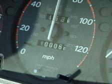
I last wrote on May 15. On May 16, we chased with George in Kansas, but didn't see much ... just some mushy storms and a few lightning bolts. And my car's odometer turned over 100,000 miles somewhere near Liberal, Kansas.
The next day, storms fired way too early. We stopped in Woodward, Oklahoma, to plug in the laptop and get data early in the afternoon, and when we came out of the truck stop a few minutes later, the sky had exploded in storm anvils. So much for my target of the Texas panhandle! We were suckered by these early-firing storms in central Oklahoma, which went severe and then died as we went after them. It seemed too late to go west, though some interesting storms fired there. We gave up for the day and headed to Norman, Oklahoma, our home away from home. That night, after 3 a.m., we had a great lightning show as a squall line ripped through the Oklahoma City area. Quaking rolls of thunder woke me up, so I opened the curtains on the window in my west-facing room and watched the bolts strike. Then the wind and rain rose like a wave over the roof of the Golden Corral next door, lit up by the parking-lot lights, and a moment later, the squall line hit with huge winds, brilliant flashes and the occasional small hailstone.
Saturday, May 19, was the first day that felt like a real chase, with the possibility of tornadic supercells. The potential for rotating storms was good ... and then ...
Storms went up too early in the eastern Texas panhandle and western Oklahoma, but there was still potential in and west of Childress. First, Dave, George and I decided to check out the storms going up to the north, since they were so close ... and there was a tornado warning on one cell. Yet it had lost its tornadic potential. We quickly realized that the storms were kicking up lots of dust and spewing cold air. In other words, they were outflow-dominant, which means they were croaking. Worse, they were pushing out an outflow boundary, a rush of cold winds that overtook the entire area. All of our southern, warm, juicy, favorable winds were blown into oblivion and became northerly gusts. So as storms went up, they lost almost all potential for rotation.
We ended up in Seymour, Texas, amid massive chaser convergence. I ran into lots of folks I knew, including Arizona chasers John Moore and daughter Beth, Jim Williams, the "Twister Sisters," Greg Brenneman, National Geographic videographer Dave Linstrom, Keith Brown - who was with the Doppler on Wheels trucks that pulled up at a gas station across the street - and some folks I'd met only recently. After some frolicking and junk food, Dave, George and I decided to drive northeast to get into position for the next day. In short time, north of Archer City, Texas, we got into the small hail of the core of a storm we thought was harmless - and then a tornado warning was issued over the radio! Dave found a radar image on TV, and we used it to try to negotiate the roads to get near the notch in the storm, where there might be circulation. All we saw was rain and hail, though we heard another chaser saw a rotating wall cloud - the area where a tornado MIGHT form - but no tornado.
After a brief lightning show at our hotel in Denison, Texas, we got a little sleep and got psyched for Sunday. The Storm Prediction Center's discussions of the day's potential included all kinds of signs of doom, and the other data seemed to bear out the potential for tornadoes. We hovered on the Texas-Oklahoma border at a truck stop, checking data on the laptop, then headed into Oklahoma to Atoka in the early afternoon to get nearer to where the action was, in the PDS tornado watch box - or "particularly dangerous situation." A quick Internet radar check revealed a couple of storms had already gone up north of us, on the boundary. We started heading that way.
Ahead of us on Route 75 were two Doppler on Wheels trucks. We took this as a good sign, but the circumstances were not good. Chasing in eastern Oklahoma is challenging, to say the least. There are massive hills and lots of trees. It's very difficult to see storm structure. And rain makes it even worse, and boy, did we get rain - but not yet.
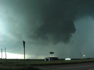
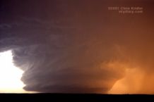
We chose to pursue the western storm. First mistake. The eastern storm, near Dustin, was producing about the only photogenic tornadoes of the day, unknown to us. Our storm had a wall cloud, but it didn't look that good. We decided we needed to get to the eastern storm. After several excruciating minutes of driving on Route 9 through blinding rain, whipping winds and hail - and past tree and telephone-poll damage from a previous tornado - we got in the clear, just in time for the eastern storm to weaken. It was being overtaken by the western storm, as radar on the TV made clear. So in true storm chaser tradition, we changed our minds and decided to go in a circle, of sorts. We dropped south, then slightly west on Route 52 and ended up on an overpass over the turnpike. A circus was unfolding below. Cars were stopped up and down the highway, and a guy was sitting atop the overpass, looking at the tornado-warned storm bearing down on the crowd. "I'm safe," he told me. "We can hide under this overpass." I replied: "This overpass is no protection. If a tornado hits while you're under there, it will kill you." I advised him to seek better shelter. People were killed during the big 1999 Oklahoma City tornadoes when they hid under overpasses. I decided to be blunt.
The storm paid no attention to the circus. To our north, the new meso (mesocyclone, or area of rotation) was hanging majestically over the road and was moving east rapidly. We were in trouble, not because we were in danger, but because we had no road options. We couldn't retrace our steps, because the storm was moving too fast and had overtaken the road. We had to go east on a road that went out of the tiny town of Hanna. And boy, what a road that was! We had to negotiate huge hills and curves on a narrow, bumpy road that was only occasionally paved. Meanwhile, we had to stair-step north to get back to a real road, which meant flirting with the area of rotation while our view of the meso was continually blocked by trees. We were facing a deadline, as well: If we didn't get off the dirt road before the rain hit, it would instantly turn to "pudding," as George put it. We'd be stuck.
As the first raindrops fell, a dark, newly paved stretch of road with a bright yellow line opened up before us. I felt like Dorothy, ecstatic upon seeing the Emerald City for the first time. We hit the paved road as the rain and hail slammed us. The hail probably didn't get much bigger than quarter-size, but it was enough to add some more dimples to my hood. Then we were back on Route 9, heading east, trying to get out of the blinding precipitation.
Another tornado warning was issued for the storm, for an area of rotation north of where we were. Meanwhile, we were hearing warnings on the radio and television for all over eastern Oklahoma. But on the whole, these weren't big, photogenic tornadoes that could be clearly seen. These were more dangerous - wrapped in rain and nearly invisible. As we headed east, we were keenly aware of which direction the wind was coming from. If the wind suddenly switched from north to south, that would indicate a tornadic circulation to our north. On the western edge of Stigler, the winds suddenly turned southwest, then south. "OK, here we go!" Dave said. I was looking immediately to our left, less than a mile north of the road. "That could be a tornado! I think that's a tornado!" I was saying. I turned my video camera quickly toward the coneline blob that briefly appeared in the rain as I accelerated. I saw a police car that was observing the storm north of the road back suddenly into a car wash. I suspect the officer saw what we saw - whatever it was.
Certainly, we were in a tornadic circulation, if not just south of a tornado, and my adrenalin was high. It's the first time I ever felt truly in danger from a storm. In town, the sirens were screaming. Some guy was poking along ahead of me as if he was out shopping for flowers. I flashed my lights and he moved over. At a red light, I stopped, made sure no cars were coming, then went through with my blinkers on. Dave was aghast. I said, "It's a #&%*$ tornado, Dave, I'm running the red light!" As we pushed through town, rain curtains ahead of us were clearly rushing from right to left, wrapping around the area of rotation. We were in the "bear's cage," no doubt about it.
Finally, we broke clear to the east and had the first decent view all day of the beast. A huge, greenish core was filling in the meso. Lots of cloud motion was on the curved front edge, and a shelf-like cloud feature could be seen to the north of the rotation. 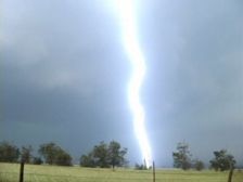 Hot lightning was striking everywhere. At one brief stop to videotape it - all of our stops were brief, because it was moving so rapidly - a bright bolt hit probably a quarter-mile from the car. The bolt itself didn't surprise me, but the nearly simultaneous sky-ripping crack and bang of thunder almost made me drop the camera. I was breathing as fast as a rabbit for several seconds afterward. Scary stuff, even though I was in the car, which provides some protection. Lightning can kill you. That didn't occur to the guy standing nearby, in his front yard, watching the storm come in. "You might want to seek shelter!" I shouted out the window as we drove off his little farm road and back onto Route 9, headed east.
The HP or high-precipitation storm soon became a less appealing, less chaseable object as darkness began to fall. We headed south to another storm that had a pronounced hook on radar. Dave's radar updates from the TV had saved us all day - or perhaps lured us into danger - and because we knew where the dangerous area of rotation area was on the new storm, we stopped in Wister, Oklahoma, to let it pass. That's Wister, "as in twister," as Dave said.
When we finally gave up for the night, we grabbed some food at a nearby McDonald's and then headed west toward McAlester, where we'd made hotel reservations. We were tired of chasing - but still had to drive through multiple severe storms to get there! I was fried. I'd been driving all day. And when the lightning is strobing constantly in the darkness, the human eye simply can't adjust quickly enough. So my eyes hurt, my bones hurt, and anyway, enough whining ... we finally got there and found that three other teams of chasers had checked in before us. Among them were Bill Hark and Kinney Adams. We said hi and enjoyed a lightning crawler show before crashing for the night.
It's been a calm couple of days of recovery. Last night, a bunch of chasers got together in Norman to watch "Shrek" (very entertaining!) and grab dinner. Among them were Keith, Bill, Dave Fogel, Jason Persoff, Shane Adams and some other folks. Back at the hotel, Bill, Dave, George and I had some cake (with a tornado on it, of course) to mark George's 31st birthday. He said he made a wish for all of us when he blew out the candles - and we all know what that means. Though I'm too superstitious to mention the "T" word.
That's it for storm action, for now. Tomorrow, caves and storms, I hope. This has been one of the driest storm-chasing seasons I've experienced. But I'm trying to look at the bright side (it's too bright, actually - I'm getting sunburned). And at least I've had one memorable day.
June 2: On the road in Oklahoma
Today, I start my drive back to Florida, after a great final week of storms. Meanwhile, Dave is driving us to Norman, Oklahoma, where he'll remain to chase with the Cloud 9 Tours folks for a couple of weeks. So I have a few minutes to recount the agony (hail trashed my car) and the ecstasy (a beautiful tornado, or possible tornado, in Colorado).
The last time I wrote, we were about to see the caves at Carlsbad, New Mexico. We went through the main caverns on May 24, which was a good hike and more strenuous than I remembered. It's about four miles, the first half of which is a steep descent into the cave on a switchback trail. My leg muscles were trembling by the time we hit the lower chambers. The caves are awesome, a kind of underground cathedral hung with chandeliers of glistening mineral formations and bristling with spikes and curtains of rock. Unfortunately, we didn't stay to see the evening bat flight (another reason to go back), as we booked east toward the place where storms would fire. Fire they did, far south in Texas, and we couldn't get on the south (i.e. picturesque) side of them in time. Still, we were treated to a beautiful sunset before our evening in San Angelo.
The town was rife with giant black beetles, which are apparently swarming all over Texas this year, along with a profusion of irritating moths. In some places we've visited, there are so many beetles they're crawling all over each other and the walls, cannibalizing each other, carrying around the heads of their dead buddies, and giving off a sickly sweet stench when smushed. In short, yuck.
The next day was a pure bust near Junction, Texas. Dave and I met up with Bill Hark and sat around for hours, waiting in vain for nonexistent storms. So did other chasers all over southern Texas, as we found out when we met a bunch for dinner in Abilene.
May 26 was much more promising, a good dryline chase day in the Texas panhandle. When the first two storms went up, Dave, Bill and I headed toward a storm near Matador, Texas, and, inevitably, ran into the Cloud 9 Tours group again as the LP (low-precipitation) storm evolved. It looked good for a while, but soon storms were mushrooming all over the panhandle, and the result was a giant cluster of precipitation and chasers. We followed some nice stuff, then finally decided to drive through some rain and hail to see what was on the other side.
Let me point out that I never drive through hail if I think it's big. This hail was not particularly big. I say this now lest you think me an idiot when I tell you about the hail from hell, which we went through a few days later.
So ... we got through the hail while following a mobile radar from the University of Massachusetts, as light filtered through the curtains of precipitation and hot lightning hit all around. The sight on the other side was spectacular. In the clear air, we looked back toward the east to see the hail falling out of the storm in a brilliant white curtain, with a hailbow - a rainbow produced by hail! I could barely stand up to videotape it as cold outflow winds blasted toward us. We attempted to circumnavigate the core and get back east into better position, but the storms had turned into a squall line, and instead of chasing them, we enjoyed the mammatus show. Fields of the pouchy clouds were hanging from the anvils of the storms, side-lit orange by the setting sun.
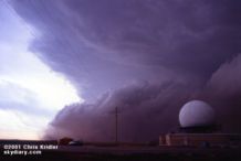
May 27 was a blast, or, you might say, a sandblast. Dave, Bill and I met up with Steve Sponsler and headed up into Kansas. We had hopes for supercells, but most storms were going up early and beginning to merge in a messy line. At a truck stop in Sublette, we looked at radar images and weighed our options as the sky outside became more and more ominous. By the time we headed north, it was too late to get individual cells ... the whole mess had merged into a great line, a dramatic shelf cloud rolling toward us, kicking up brown dirt underneath it as it went. We stopped by a radar dome and got video and stills as it approached. Then the first dust hit. It was a haboob, a Dust Bowl storm, a roaring animal.
We leapt into our cars and headed south again to the truck stop to take shelter under the roof, in case there was hail to contend with. Instead, we were blasted with winds that some people measured at 80 mph or higher. The dust and gravel from the fields and parking lot pelted the car as the winds knocked over trash barrels and sent bits of branches zooming by. We saw a bird flying backward - it couldn't compete against the inexorable winds. After several minutes of sandblasting, it was pretty much over, with no hail, just some rain. We looked at some other pretty convection, then went our separate ways.
On the way to Woodward, Oklahoma, where we had hotel reservations, Dave and I saw a lot of damage from the straight-line winds - trees knocked down, a blown-over tractor-trailer and power outages. We ran into Bill at the gas station in Woodward, had some pizza and crashed for another night.
Upslope storms - the kind that form on the higher elevations near the mountains - seemed the best bet for May 28. The phones were out in the hotel, which was a very plush Super 8, I might add, so we got the basics on the day's outlook from Jay Antle and began meandering west. We met up with Ed Roberts from Kansas City and some other chasers in Guymon, Oklahoma, who kindly shared some data files they'd pulled, and we headed farther west. In Dalhart, Texas, a nice woman at the Holiday Inn Express let us plug in for a few minutes to get more information, and we headed for Clayton, New Mexico. If you're counting, that's three states already.
A field of low clouds was obscuring our view, so Dave called Philip Flory, a teenager who knows way more about weather than I do. He's been doing some "nowcasting" - recounting current conditions, storm positions and so on - for chasers this year. He told us of a nice storm going up in Colorado, so we headed that way. And boy, am I glad we did. We were treated to a succession of nicely structured, LP storms coming off the mountains. The first couple died, however, after forming in the same place. We decided to get closer to their point of origin and, north of Trinidad, Colorado, ran into Scott Blair and Jason Politte from Arkansas. A spurt of hail later, another, beautiful "mothership" storm formed over the mountains, visibly rotating and producing a wall cloud and what looked like a funnel. We followed it northeast a bit, and though it looked as if it wanted to produce a tornado, it followed in the steps of its brethren and fell apart as the sun set.
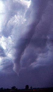
Yet another storm had formed just behind it, and this new meso - mesocyclone, or area of rotation - was classic. About a mile from us, it exhibited all the signs of a forming tornado. A rear-flank downdraft cut in, creating a visible clear area as the circulation tightened into a funnel. As it got closer, the funnel elongated, clearly spinning, stretching nearly to the ground and becoming pointy. This was most likely a tornado - there was certainly circulation on the ground, though we couldn't see debris there. As it danced its slow ballet in the glooming dusk for about 10 minutes, the funnel elongated and then evolved into the wispy rope stage, a slim snake curling in the air and then dissipating. What a show - and we were right next to it!
The meso was still strong, and we were tempted to follow it. We did, for a bit, but chasing a tornadic storm in the dark in the rain is not safe. We stayed to the southwest of the meso for a bit, watching it being illuminated by lightning, then gave up for the night. After dinner with some other chasers who'd had a great view of the tornado from a bit farther away, we headed back to Clayton for the night.
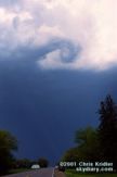
May 29 promised serious tornado potential that was only partly fulfilled as several discrete storms formed along the Texas dryline in a strongly sheared wind environment. Dave and I monitored radar at a data stop in Vega, Texas, then went after almost the first storm that formed, south of I-40. It took a while to get organized, but several times, the rear-flank downdraft cut in and tried to spin up a tornado. Soon, the thing was a giant rotating beast, and at one point, a massive RFD was kicking up so much dust, we were sure it was going to do it. Meanwhile, we were navigating around more chasers than I'd ever seen on a storm - dozens of cars on a tiny farm road, tourists, researchers, mobile radars, you name it. It looked like rush hour.
We heard a tornado-on-the-ground report from a storm farther north, but we didn't want to leave our supercell, and as we got ahead of it I was glad. The thing had a structure unlike any I'd ever seen. First it seemed like a big flying saucer, sucking in red earth near Quitaque. Later, it was a wedding cake, visibly rotating. Then, at sunset, it was almost like a barrel. We watched it spinning near Childress, where the tornado sirens were going off. Though it never produced a big tornado (as the storm near White Deer did), it was a gorgeous, dramatic monster that spit out a lot of small spinups, and I'm thrilled that I saw it.
As you can see, we haven't had much of a break, until we had to take one to fix the car. Which leads me to May 30. Though there was a better risk of severe storms in southeastern Oklahoma, the wind profiles weren't good for supercells, so we decided to play the upslope in New Mexico. We joined up with Scott and Jason again, and as we approached the New Mexico border, we saw a full-fledged supercell already sprouting by 1:30 p.m.! We booked to it as quickly as we could and up a steep mountain road to the town of Mosquero, New Mexico. The storm slowly began to organize, rotating cyclonically (counter-clockwise) at the mid-levels and, at least to the eye, anti-cyclonically at the lower levels. As it, and we, came off the mountain, the thing was clearly a beast, with a large white-and-green hail core. It also looked more linear. Convinced it was gusting out, we headed east, then noticed that it had begun to reorganize. It was another beautiful rotating storm, with a wall cloud and what might have been a funnel under it!
Keeping up with it on the terrible New Mexico road network proved nearly impossible. It was moving southeast. Our strategy was to get on the interstate and get ahead of it, going east. We quickly fueled up, then headed east. The weather radio said the storm was moving slowly. It wasn't. We thought we could easily get past the storm - until it was on top of us. This supercell was quickly cycling through mesos - old ones were being rapidly wrapped up by curtains of hail and rain, and the storm had gone through half a dozen such cycles before it hit the interstate. Unfortunately, we met it there, at mile 6 in Texas on I-40, east of Glenrio. Hail wrapped behind us before we realized how fast it was going. Our speed couldn't get us into the clear, which we could see just ahead. In the span of a few seconds, Scott was on the radio, saying he saw dime size hail - bigger than dime size - baseballs hitting the road!
"Did he say baseballs?" I said. It was too late. BAM! One of the first big stones took my windshield, putting big circular cracks in it. We couldn't outrun the storm without intensifying the force of the collisions. We had to pull off as the barrage began in earnest. The size of the stones got a bit smaller, but these were high-plains tennis balls and golf balls, rock-hard ice formed by cold air aloft. I was scared, but I had video rolling. I held the road atlas up to the driver's side window to protect myself in case it shattered and felt it wildly vibrating, radiating the cold caused by the hail that was slamming it. The stones were blowing almost horizontally, probably at 70 miles per hour. The car was rocking. As the onslaught lightened a bit, I tried to move my car back a bit and straighten it out - I'd angled it so the hail wouldn't be hitting the side windows dead-on. We were stuck, but a few attempts forward and back, and we were released from the mud.
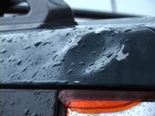
The hail attack, which started about 6:40 p.m. central, continued for probably 10 minutes. When it was over, all of us had lost lights - the entire column of taillights on one side of my car was completely bashed out. I'd lost the only window, the front. Jason and Scott had serious damage to their antenna racks, mirrors and other parts of their cars. In fact, Jason's had quit and couldn't be restarted. He realized later that the fuel switch had automatically turned off because the car thought it had been in an accident.
And then there were the dents. ARE the dents. These can't be fixed. The hood, roof and entire left side of my car look like rippling water. Plus there are a few serious craters, especially on the back left corner. The hail even chipped some paint off. So the next two days, I was making phone calls and arrangements and repairs. The windshield's been replaced, the chips have been touched up, and thanks to Dave's engineering instinct, the taillight piece was replaced in about five minutes (after I spent a lot for the part, of course). We found out we were almost lucky ... when Scott and Jason went back to get Jason's car, they saw a tractor-trailer a few miles west of where we were with lots of bashes and multiple smashed windows. Softball hail was reported west of us. The damage could have been much more serious - to both our cars and ourselves.
So ... Dave and I chased yesterday, June 1. We got on more spinning cells in Kansas, beautiful things that had such huge RFDs, the downdrafts practically ripped them apart. As we were watching one nice storm with a decent meso, the Cloud 9 Tours folks pulled up, and immediately started filming - my car. Yes, it's that wild looking.
We saw some funnel clouds out of the storms before they simply evaporated from the bottom up, still spinning, as they apparently ran out of moisture. Great photo ops, and a nice way to end the chase. We met up with Jason and Scott, as well as Matt Crowther, Betsy Abrams, Jay Antle, Mike Umscheid and their crew at Casey's Cowtown Steakhouse in Dodge City, which was allegedly the best restaurant in town. It was fun, but if you want a really good restaurant, you might want to go to another town.
Now I face the horror of driving across the country. I had a dream about teleportation last night. It would be great to teleport to storms ... or teleport home. But it doesn't work that way.
Go to this year's chase accounts and photos:
- February 14-March 31: Fog, a few storms and blue-sky distractions in drought-stricken Florida
- May 6-8: Roiling severe storms in Oklahoma and a mothership in Kansas
- May 9-11: Pretty storms in Iowa, Minnesota and Missouri
- May 16-19: Lightning and downpours during a Kansas chase and an outflow boundary from heck in Texas
- May 20: A too-close encounter with a tornadic supercell in Oklahoma
- May 23-27: Dust devils, Texas storms and a dust-bowl-style gust front in Kansas
- May 28: Beautiful storms in Colorado and a tornado at dusk
- May 29: A monster, rotating, layer-cake supercell in the Texas panhandle
- May 30: A gorgeous storm from New Mexico that produced hail from hell
- May 31-June 1: A look at Texas tornado damage and pretty rotating storms in Kansas
- June 3-24: Severe storms and fantastic lightning in Florida
- July 3-August 4: Shelf clouds sweep over the water in east-central Florida
- August 10-11: The Florida Keys offer a skinny waterspout and shimmering sunsets
- August 17-23: Florida again proves itself king of the shelf clouds, lightning and sunsets
- August 31-September 24: A layered gust front, lightning and the remnants of Tropical Storm Gabrielle
go to the main gallery page | go to storm chasers
go to reports from 2001, 2000, 1999, 1998, 1997