
:: books
:: gallery
:: data
:: blog
:: kids
:: shop
:: bio
:: help
:: contact
:: ChrisKridler.com


|
Words/images COPYRIGHT © 2021 by Chris Kridler. All rights reserved. Do not use Sky Diary photos on other Web sites. Personal use as computer wallpaper is permitted, but do not distribute photos. Write for information about purchasing video, photographs or articles. | Frequently asked questions |
storm gallery: chase diary 1999
Here's a collection of bulletins from the field, written during my 1999 storm-chasing trip in the Great Plains. They are slightly edited, but they give a sense of what it's like to live life by the sky. Dates reflect when each bulletin was written.
May 11: Motel 6 in Denton, Texas
There's nothing like hitting the ground running, or hitting the road driving. On Saturday (May 8), Dave Lewison and I drove from Baltimore to Springfield, Missouri, in order to be in range to chase storms the next day. That was Sunday, and we drove all the way to western Oklahoma and the Texas panhandle.
There was bad visibility -- the storms fired in a mean, mushy line, so it was difficult to make out any structure. With the help of Allan Rosenberg giving us hints on the phone, we got in front of one storm and got some footage of it rolling into Quanah, Texas, then went south to Crowell. There, a rain-wrapped beast (i.e., it was impossible to see what was going on inside of it) was approaching the town. When the radio issued a tornado warning for the storm, which was practically on top of us, we scooted east darn quick, as it was getting dark and we couldn't see what was happening. It was a radar-indicated warning anyway, which means there probably wasn't an actual tornado involved.
The next day, after lunch with a couple of chaser pals, we headed to northern Oklahoma under partly sunny skies to see if storms would fire. On the way north on I-35, we passed a small portion of the F5 tornado damage in Moore, Oklahoma. It was staggering. Photographs can't do it justice. It's as if the neighborhood went through a blender. It's humbling just to see it.
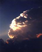
We reached our target town in northern Oklahoma. After much hanging around at a convenience store and the local Sonic drive-in eatery, we were about to give up ... but still, we kept an eye on some aspiring cumulus to our north. And lo and behold, one of them started to look good -- a firm tower was going up, so we turned north and began to pursue it. It grew a large anvil and kept building at the back of the storm, getting bigger and bigger. No rotation was evident, but it was a beauty, and as it sprouted a big anvil, the light from the setting sun hit its crown. We finally got close to it, crossing the border into Kansas, but could see no wall cloud (from which a tornado might form). Still, we watched it for quite a while as it got dark. It produced a great lightning show and then started throwing out quarter-sized hail. PLUNK! PLUNK! Worried about getting major dents, we booked out east ahead of it. Once we got far enough, we were able to park the car on a deserted farm road and take some lightning video and time-exposure photographs. Spectacular anvil crawlers were lighting up the sky, like iridescent spiders. The drawback: We got back to the hotel in Norman, Oklahoma, at 3 a.m.
Today, after another chaser lunch at another "trough" -- the fond nickname for those popular middle-America cafeterias -- Dave and I headed south for a slim chance of severe storms in north/middle Texas. We got 'em, all right, but were never in position to see anything really good. Then again, there wasn't anything really good to see, except some lightning, torrential rain and a little hail. It was another day of driving hundreds of miles. The car has gained close to 3,000 since Saturday. And we've eaten dinner at Denny's two nights in a row. Help!
Still, I'm happy to be out here on the open road, staring at the sky, living for the moment. And I have hopes for better storms later.
May 18: Super 8 hotel in Norman, Oklahoma
I know it's a long time between updates, but I've been absolutely crazed. This is the first good down day I've had in ages. I'm actually grateful for blue skies today so that I can deal with laundry, bills, etc. I even had a SALAD with lunch today! Actual green leaves! You would not believe how much junk and diner food one consumes on the storm-chaser diet.
So ... after a day of driving back to Norman last Wednesday, getting film developed, etc., I had a fun evening watching other chasers' storm video, including Jim Leonard's amazing footage of one of the May 3 tornadoes. It wasn't the one that hit Oklahoma City, though he did see that storm at its genesis and got footage of it producing one tornado early on. But he jumped to another storm and captured a spectacular, large, white tornado moving through a field, with the texture of cotton candy.
Thursday, a three-person BBC crew hooked up with Dave and me. The BBC has lots of crews out here, following around chasers, scientists and so on. That day, we drove up into Kansas to get into position for the next day, because western Kansas/southwestern Nebraska looked good. Friday morning, the forecast wasn't as obvious, as Texas looked to have potential too. But we pored over the data and decided it would have to be southwestern Nebraska, where a small clearing in the cloud cover would allow for daytime heating and thus provide fuel for storms.
It was a relief to get out of the clouds that were over Salina, Kansas, and into the clear. We paused at a truck stop to get more data and saw that a tornado watch had been issued for our target. That got us a little more excited, so we blasted northwest over some lovely, empty farm roads and into the area where storms were already starting to fire. We got close to one that had a tornado warning on it, but no apparent tornado -- it quickly lost its organization and turned into a gust front, or rather a dust front, as huge, billowing clouds of red dirt blew at us. We tried to get into position to chase something better, but the storms were turning into a furious line and we ended up getting hammered by hard rain and small hail.
We stopped at a gas station to let the worst of it pass and saw the VORTEX research team buzz by. As the storm cruised past, the light was incredible, and a rainbow hovered before us as we sped off toward another tornado warning. No luck there, but the storms were a sight to see, sending lightning across the sky and glowering on the horizon.
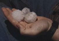
Then, things got nasty. We decided to head for a town in Kansas to get into position for the next day and thought it would be a relatively easy drive. No such luck. The line of storms kept developing to our southwest, continuously pounding us, as we drove east, with fiercely intense rain and hail for, literally, hours. We briefly turned around a couple of times to avoid the big hail. When we resumed our course, we found so much hail on the road, it was like driving on gravel. It was even producing a "hail fog." We stopped for a second and Dave picked up a few of the 1.5" stones -- and saw bigger stones by the side of the road.
In Stockton, Kansas, under yet another severe thunderstorm warning, we gave up and found an old motel. We got soaked running the six feet to the door to register. I felt bad for the BBC crew, who'd been following in their own van -- I knew how exhausted *I* was from the drive, and they had never seen rain like that before.
The next day, Saturday, the forecast looked a lot more unlikely than it had the day before. The cloud cover, or "convective debris," as the Storm Prediction Center so charmingly called it, was inhibiting the all-important daytime heating. We drove west for a ways, looked at the data again, and decided that any storms that might pop up would be garbage anyway. So we parted ways, with the BBC heading off to join another chaser and Dave and I beginning the drive back toward Norman, so that he could join Cloud 9 Tours on Sunday. Later, we found out that a tornado had occurred in the Stockton area, where we'd spent the night!
Sunday morning in Kansas, when Dave knocked on my door, it was clear that we were looking at big potential for storms, as there was lots of moisture in the air, it was sunny, and a cold front, low pressure and a diffuse dryline were setting up. He was willing to put off the tour a day -- since the group wouldn't be chasing, just having its orientation party -- so we headed toward central Kansas. In Great Bend, a convenience-store clerk was nice enough to let us use the phone line to check the data. We picked a target slightly east of the center of the state, where the dewpoints and convective potential were nearly off the scale.
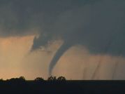
We fueled up in McPherson under "turkey towers," skinny cloud towers that seemed to bode well for storm towers later on. The cap, or layer of warm air, hadn't been broken yet, but the clouds were a good sign. We got a little east of the main area of convection, and then the sky began to explode. A few of the towers quickly began to build, breaking the cap and then shooting upward and gaining mass and strength. Their sheared appearance was a good sign of rotation. We kept up with the biggest one. Then I saw something suspicious -- it looked like a funnel was angling out of the base of the storm. It took me a couple of minutes to convince Dave as we sped along, and finally, it was clear -- a quick, distant, needle-like tornado, which caused some damage in Enterprise, Kansas.
As that storm lost cohesion, we dropped south, where a whole line of storms was going crazy. We paused for a while looking at one storm and hearing tornado warnings, then dropped farther south to see a meaty-looking twister as tornado sirens eerily wailed nearby. Again, we only got several seconds' glimpse -- and again, my video stinks, since I was driving -- but it roped out (got a snaky appearance in its dying stage) and for a moment looked like something out of "The Wizard of Oz." We stopped on a farm road, where we met up with Don Lloyd, who'd had a good view and filmed it.
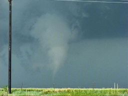
Again, Dave and I dropped south, driving through the town where the sirens were wailing, and pulled off on another farm road, keeping an eye on what looked like two areas of circulation. Then -- one produced. It was a beautifully backlit tornado, and we managed to get a couple of minutes of video as it set down and then roped out. (No still photos; I was too distracted at the time! Plus it was a little distant; thank goodness for zoom lenses.)
The sun was setting fast, and the storms were aglow, but the ones we'd been chasing were losing their power. It was time to get Dave back to Norman. So we headed toward the interstate and, to avoid driving through another several hours of pounding rain, stopped in Wichita to get some food. We unwittingly stopped at a coffee shop in a flood-prone area. As the rain poured and blew in hurricane-like gusts, sky-ripping CGs (cloud-to-ground lightning strokes) were zapping the city, hitting nearby poles and disrupting the electricity more than once. As the torrent waned, the waitress suggested a route to avoid the flooding. But the alternate route was almost as bad. We managed to get through, but on a parallel street, cars were halfway submerged, their headlights barely showing in the water. And the huge drainage canal that runs parallel to I-35 was gushing, halfway full.
The worst of it was over for us, however. We made it back -- another late night -- and Dave joined the tour. Yesterday, I chased by myself but ended up seeing very little of the line of storms that went through Texas. They weren't that exciting anyway, which was small comfort for wasting a day and using up a whole tank of gas when I could have been catching up on my sleep.
And today, at last, I'm doing laundry and errands and maybe even going for a swim in the pool. I also have to try to forecast when the next chase day will be. The pattern is quiet right now.
May 23: Motel 6, Hays, Kansas
This trip is going by so quickly, it's hard to remember what day is what. But May 20, Friday, is an easy one to remember.
I was chasing on my own. I headed from Norman, Oklahoma, to Shamrock, Texas, to check data at a truck stop, where I ran into some old friends from Cloud 9 Tours. After a nice reunion and another run-in with another BBC crew that was following the group (they're EVERYWHERE!), I decided to head west on I-40 a bit, where many elements were in place for severe storms. Among them, the dryline was pushing into the Texas panhandle, and a small line of cumulus clouds was appearing on the satellite image, so it seemed like a good place to start.
Almost as soon as I reached my target, I saw towers going up. I drove a little north on Texas highway 70; one storm quickly died, but another slowly built, evolving, sucking in moisture, growing a "beaver tail" cloud formation, hinting at lowerings. I wasn't convinced that it would do anything, but since it was currently the only show in town, I decided to stick around. I seemed to be the only chaser in sight, though I eventually saw a couple of VORTEX research vehicles.
Then the storm starting cranking, showering me with small hail and picking up speed -- as well as moving south, which is very unusual and indicated that this storm had potential to produce something more than rain. I met Tim Marshall, a well-known chaser who runs a magazine called Storm Track, and then, all of a sudden, there were about a HUNDRED chasers on this storm! It was unbelievable. Lots of geeky cars bristling with antennas, leap-frogging as they pulled off the road and pulled back on.
Just north of the Interstate, those of us who had waited to flee the storm were rewarded with an up-close-and-personal look at a strange white tornado to our east that touched down briefly in a field and then stretched out weirdly as it dissipated. It was beautiful. As the clouds churned overhead, I decided to head south again to avoid having a gustnado (a little spin-up; I had already seen one) land on my head.
South of the interstate, I saw two more well-developed funnels form, though they didn't touch down that I saw. At one point, it really looked like the storm was getting its act together to produce a big tornado, but it did not. Still, more tornadoes were reported on it; though I was on the storm the whole time, I didn't see those. It was a huge storm, so it's conceivable that something formed out of my sight.
I counted myself lucky, because I wasn't stuck in the hail core. The Cloud 9 group, which had headed south when I went west, ended up having to approach the storm through the hail. Though the group saw the tornado, a couple of the vans were dented up and lost windshields to 5" hail! That's HUGE. We're talking grapefruits. I wish I had seen the hail, but I'm glad my car didn't have to experience it.
I had a down day on May 21 and took the opportunity to hike in beautiful Palo Duro Canyon, just southeast of Amarillo. I took lots of photos of wildflowers and blooming cacti, and tried to capture (on film) a keen green lizard. Then I drove to Garden City, Kansas, to get in position for yesterday's chase.
I probably should have stuck to my original forecast yesterday -- for northwest Kansas -- but I was lured by upper wind divergence and ended up heading a little farther east. Storms were going up everywhere. I picked a really meaty one and headed north into Nebraska to intercept. It turned into a spectacular gust front that kicked up great walls of dust before it. It then chased me back into Kansas. I've never seen green in a storm as I did in that one -- there was literally a kind of teal color within. The color and reflectivity almost certainly meant big hail, so it was important for me to keep ahead of it.
I chased, or was chased, for a couple of hours and stopped to take photos of the amazing shelf cloud the storm developed. It took on a fantastic layered appearance as it crunched south. I parked by a lake to get a couple of photos and told the people fishing that there was a severe thunderstorm warning. All left, but then a couple of anglers arrived and didn't CARE that there was a warning. "Oh, I've seen worse," one old guy said as lightning struck nearby. DUH! Fishing poles. Flat lake. Lightning. You do the math.
Eventually, this south-moving storm collided with some east-moving stuff, and as darkness fell I got a room in Hays, Kansas, for the night. There were a few confirmed tornadoes yesterday, says The Weather Channel, though of course I didn't see any of them. But I did see quite a show.
Today, I probably won't chase. The prospects are slim and distant (in New Mexico). Maybe I can finally get in that movie -- what's it called -- you know, the one with the spaceships ...
May 27: Motel 6 (yet another one!), Fort Worth, Texas
Well, the trip is more than two-thirds over, and I've put more than 8,500 miles on the car. I'm truly sick of diner food. But the wonderful storms keep on coming.
I drove in a big circle on May 24 from Amarillo, Texas, to Roswell, New Mexico, and back into Texas, seeing cloud towers corkscrew and collapse all day. I should have stuck to my original forecast -- closer to Roswell -- because that's where there was a tornado warning. (Plus, maybe I could have seen a UFO.) That's OK; when I arrived at my hotel in Lubbock, I got to experience a line of severe storms that ran over the city. There was some very intense lightning (one cell-phone tower was zapped four or five times) and heavy rain. I met a few chasers from Illinois who were also at the hotel. They had never chased Great Plains storms before and were finding out that the weather out here is a very different beast.
The next morning (May 25), since they didn't have a laptop, they looked at my data, and we ended up chasing together. We stopped in Clovis, New Mexico, for more data and ran into one of my pals from the storm-chasing tour last year, Tom Warner. The whole caravan headed west into what soon became a forest of supercells in eastern New Mexico and west Texas. We picked a cell with a severe thunderstorm warning on it, in hopes that the shearing conditions would prompt a tornado. It was a classic supercell, but the 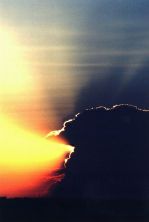 tornadic storm far to its south was probably robbing it of moisture, preventing it from gaining strength. We watched it for a while, then fled its onslaught of hail and decided to chase a cell east of us. We never caught it, since it was moving east; we ended up between two lines of strong storms, though we could see their amazing towers and anvils from great distances. We went our separate ways, and I ended the day east of Lubbock, videotaping lightning well after dark in a cell that eventually had a tornado warning issued on it. (I didn't pursue it; it's hazardous chasing such storms at night!)
On May 26, I met up with the Illinois chasers again, and we ran into a chaser convergence at Big Spring, Texas. On hand was the Silver Lining Tours group, as well as Dr. Howie Bluestein of the University of Oklahoma and his mobile radar. I introduced myself to him since I'd once interviewed him for an article. After getting data at Midland, Texas, and running into more chasers, we headed west to keep an eye on a cell coming out of Carlsbad, New Mexico. Few road choices and the momentary allure of another cell meant we weren't close to it when a "tornado on the ground" warning was issued. We came back to it from the east. Under a nice wall cloud, a very suspicious-looking lowering formed. I reviewed my video, and I think it was possibly a tornado, but I can't say for sure. We couldn't stick around long enough to examine it or get closer because, for one, it was becoming rain-wrapped and thus invisible, and two, the storm was beginning to form a vicious, hail-filled gust front that was already looming over our heads, cutting into the sky like a giant black spaceship (think "Independence Day"). We turned tail and zoomed east at warp speed, but not before we spotted Dr. Bluestein's mobile radar vehicle roaring west toward the heart of the storm -- perhaps toward the gap between the lowering and the hail core. We ended up in Crane, Texas, where we waited out the front and saw some truly spectacular lightning, the best I've seen this year.
Today was an off-day. I met up with the BBC crew again for a wrap-up interview. The "bad" weather should start again soon -- I hope.
June 1: Guest Inn, Norman, Oklahoma
It's funny how the prosaically named Norman has become a kind of second home. I know where the laundry is, I know where the post office is, I know where at least some of the restaurants are. Though they all close early -- I had to go to Denny's again tonight. You know, I'm starting to LIKE Denny's. Egad. Tonight, the Sunshine Slam with hash browns and a side of fruit -- fat banana slices, fork-repellent purple grapes and juicy red strawberries. Not bad.
I'm between chases (at least I hope I am -- at least that would mean I would end my trip chasing). The last few days have involved a lot of driving with mediocre results. 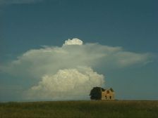 But looking at the bright side, on Sunday, May 30, I ended up taking a lot of pictures of gorgeous popcorn storms in central Kansas. They started out as silly-looking mushrooms and narrow corkscrewing cloud towers, bright white against the blue sky. I ran into a couple of other chasers by an abandoned house that was a perfect foreground element for photos. Later, a couple of the storms became severe. I followed one till well after dark, which was easy to do thanks to a full moon and its isolated nature. A spotter reported a tornado on the ground with that storm, but at about that time I saw lightning illuminate a "scudnado" -- i.e., scud clouds in a suggestive shape, but definitely not a tornado. Then a line of storms that had formed in Nebraska swept down through Kansas; I took refuge in a car wash in a small town while it went through. The winds and rain were intense.
Yesterday, May 31, was a day of frustration, as many tornadoes were expected but only a few appeared and were seen. I didn't see any of them, though I was definitely in the "hot zone" as far as lightning was concerned, as I was cornered by a great beast of a storm. Around sunset I intercepted the storm that had produced a couple of the tornadoes, but for all the time I watched it, it produced no more. At least one more was reported later, after dark, when I had abandoned it. The footage on The Weather Channel of the one large but short-lived tornado was very annoying!
Today I chased on a slim chance of severe storms, again intercepted one with a radar-indicated tornado warning as I dropped south from eastern Oklahoma into Texas and back up again, and though I saw some suspicious lowerings including what looked like a funnel, an incredible double rainbow, corkscrewing supercell structure and some golf-ball-size hail, again I saw no tornado. And I just saw on TWC that some were reported just north of where I was (with more irritating tornado footage). ARGH. I feel like an idiot. My only comfort is that it's really hard chasing in eastern Oklahoma, what with the hills and trees, so even if were on the right storm, I might not have seen anything anyway. The sky was incredibly difficult to read today -- a huge line of towering cumulus formed along the cold front, which extended from Texas up into the northern Midwest.
In pop-culture matters -- well, pop culture is hard to find out here. In trying to listen to storm warnings on the radio over the past few days, I have become intimately familiar with the country music top 40. Please kill me.
I also have to have my say regarding the new "Star Wars" movie, which I saw on Friday. Here are a few points I feel compelled to make:
- Jar Jar Binks: Stinks.
- Queen Amidala: Bland, OK, but incapable of opening her mouth all the way when she speaks. Is it the lipstick?
- The plot: Hopelessly transparent. I can't believe they're going to wait to "reveal" the villain.
- Samuel L. Jackson: I love this guy. He has about two lines. What's up with that?
- Best scene: The pod race. Excellent intergalactic "Ben-Hur" ripoff.
- Ending: Way too chipper. When in the hell is the Dark Side taking over?
- Biggest absurdity: The Darth Vader virgin birth theory.
- Overall: Flashy. Lacks gravity. Good moments. Basic fun. Cute Anakin. Cuter Obi-Wan. B-.
I'm sure you didn't need that movie criticism, but aren't you sick of reading about thunder and lightning? I haven't posted any new photos. I've been too tired and driving too much. Almost 11,000 miles on the car this trip so far.
June 7, 3 a.m.: Home, Glen Burnie, Maryland
What would possess two storm chasers to delay their trip to the East Coast and drive 27 hours straight from the Nebraska-South Dakota border? A "high risk" chase day, that's what.
It had been a frustrating week. Wednesday, June 2, I chased on what was supposed to be a good day in the Texas panhandle but turned out to be a line of severe storms wrapped in rain. There was a tornado I didn't see, many miles south of me, that was apparently visible for about 30 seconds to the VORTEX research team. I could see almost nothing in the storm I got caught in, except I got hurricane-like video of trees blowing in the gale. And a gorgeous sunset and rainbow followed. June 3 in southern Kansas and the Texas panhandle was a super-bust -- in fact, the only "dry bust" -- i.e. no decent storms at all -- that I had all month. Friday, June 4, I ended up hooking up with an entertaining caravan of fellow chasers from Wisconsin, Colorado and New Jersey and chasing storms in western Nebraska. The storms didn't look that great, so we gave up on them. Of course, the ever-persistent VORTEX research team managed to get a couple of tornadoes just after dark in an area with virtually no roads. Most of us were puzzled as to how, but I think it has something to do with the whole idea of no results, no government funding. Or perhaps their cars have wings.
Saturday, June 5, my pal Dave (who had been hanging out with Cloud 9 Tours) and I were supposed to drive back to the East Coast, but we couldn't resist chasing the "high risk" day, as designated by the Storm Prediction Center. We knew the elements were coming together for a "PDS," or a particularly dangerous situation. The only foreseen problems -- the storms would be widely scattered, and they would likely be screaming northward instead of cruising east or northeast as usual. As on the day before, there were incredibly strong upper-level winds coming from the south. That meant we had to be able to intercept the storms, because chasing them northward would be like trying to catch a galloping horse on foot.
We left the Cloud 9 group -- I had to meet up with them that morning to retrieve Dave -- but ran into them again at a truck stop in southern Nebraska on I-80, along with a bunch of other chasers. This chaser convergence is not at all unusual. Sometimes it's fun, but at other times it's irritating or downright dangerous if too many are on a storm. At this point, we were just all figuring out where to go. Dewpoints were near 70 in eastern Nebraska, which meant explosive potential should storms go up there. But there were also signs that they could initiate farther west. At the least, Dave and I knew we had to go north into the better air, and where we could intercept northern-moving storms. Near the area where we thought we might turn west, we spotted an area of cloud towers trying to form to the north. Soon one of them became a quickly sprouting bomb, and we began pursuit. It must have been moving northward at a very fast pace, because we could never quite catch it as we blasted into northern Nebraska -- and then it died.
We were at a loss and without information on where other storms might be firing, though we saw another anvil from a storm to our southwest and were tempted to go after it. At least we would be intercepting it FROM the north. Tim Samaras, a fellow chaser with a satellite dish, confirmed what we saw -- the cell we were seeing was the only one for miles around, it was big, and it had potential. When a storm is alone in such a juicy environment, it tends to go crazy. We went west to intercept.
As we got near it, we took a south road and paralleled it for a while. It had a beautiful structure, a hard convective tower that showed it meant business, and it seemed to be trying to organize a wall cloud (from which a tornado might form). But we had to get closer to be sure, so it was back north and then west through the town of Bassett. The storm was moving north at an amazing rate, possibly 50 miles per hour. 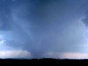 It was catching up to us very quickly. We stopped just west of the town as the base of the storm approached the road and focused on a developing mesocyclone, or area of rotation, within the storm. It took us a moment to realize that a much more impressive meso was developing practically over our heads -- a large, clearly rotating area, and we were under the northeastern edge of it. On the opposite side of the meso, we suddenly saw it -- a funnel forming rapidly in the rain. It touched down -- tornado! -- and moved out of the rain to the east and north toward the town, kicking up debris as it went. It had a healthy condensation funnel and was clearly chowing down on the Nebraska earth. After a minute or two it began to weaken and rope out, and as the meso was now over our heads, we booked east. Dave got amazing video of the top of the now-skinny funnel protruding from the storm almost directly over the car, which I was driving, while the base of the tornado was still kicking up dust south of us.
Once we got out of the danger zone, I noticed a big new meso just to our north -- the storm was moving northward, and fast. We were going to head north but changed our minds and headed east, just in time to catch an even bigger tornado north of the road. It, too, didn't last more than a few minutes, but it was impressive (even if Dr. Howie Bluestein, mentioned in a previous bulletin, parked on the wrong side of the road between us and the tornado with his research vehicle while we were filming). I haven't looked at damage reports yet, but I don't think the twister hit any houses (I heard it struck some chickens, however!). And unless a tornado hits a well-built structure, it's difficult to characterize its strength. However, Jim Leonard, who saw it too and has been chasing for more than 25 years, said it could have been as strong as an F3.
We tried to play catch-up with the storm and managed to see more signs of rotation. We even cut through the edge of the rain core to get ahead of it. But we saw no more tornadic action. The sun had set, the light was failing, and the storm was hurtling north at probably 50 miles per hour. Helicopter, anyone? We ran into Cloud 9 and a couple of other chasers (there may have been 20 or more cars on the storm at any one time) and compared notes, then marveled as the cell was lit up by lightning while stars shown above it. The vacation ended not with a whimper, but with a bang. And with the aforementioned 27-hour trip back, which began immediately after the chase. Remind me not to do that again.
Summing up the trip: 6 (maybe 7) tornadoes, a few funnels, an amazing month of storms. Lots of Texas dust and 12,000+ miles on the car. 14 hours of video. An as-yet unseen cellular phone bill, but I may need resuscitation after I get it. And about 4 hours of sleep in the past two days.
Go to this year's chase accounts and photos:
go to the main gallery page | go to storm chasers
go to reports from 2001, 2000, 1999, 1998, 1997