May 31, 2013: El Reno, Oklahoma, tornado and storm structure
May 31, 2013: I chased today with Dave Lewison, Scott McPartland, Greg Stephens, Dayna Vettese and Brad Rousseau, Bill Hark, Robert Balogh, Mark Robinson and his crewmate Jaclyn Whittal. We started the day in Norman, Oklahoma, and targeted just west of Oklahoma city at El Reno. There was a huge amount of potential for severe storms and strong tornadoes. One explosive cell produced a wedge tornado that killed several people, including three storm chasers, and emphasized the hazards of chasing anywhere near a metro area. The tornado has been rated EF5 (radar measured 296 mph winds) with a record width of 2.6 miles. Please also see my extensive blog post concerning the events of this day: Storm chasers, media, public all had role in drama of El Reno tornadoShare
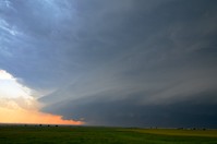
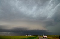
A wide view of the El Reno, Oklahoma, tornado shows its amazing storm structure in a chase that ended in a frightening traffic jam with the storm bearing down.
Click on the thumbnails to see a larger image.
By 5 p.m., three storm cells had fired and expanded rapidly just west of our I-40 exit at El Reno, so we popped west to check them out - then just as fast went back to where we'd been. Photo by Chris Kridler, SkyDiary.com, ChrisKridler.com
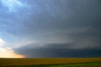
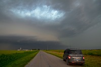
As the southern storm quickly took over and developed, we dropped south of I-40 on Route 81. I briefly went down the road that borders the airport and changed my mind. This was a very dangerous place to be later on. Photo by Chris Kridler, SkyDiary.com, ChrisKridler.com
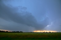
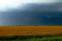
Without being close to it, it was difficult to see the development of the wall cloud and tornado. I have mixed feelings, knowing what happened later. Photo by Chris Kridler, SkyDiary.com, ChrisKridler.com
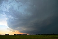
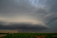
The structure was impressive, and I am cautious. So I stayed back, waiting for it to come my way. Photo by Chris Kridler, SkyDiary.com, ChrisKridler.com
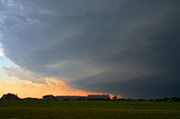
I dropped south further. I might have had a better view of the multi-vortex tornado if I'd stayed where I was, but there was a clog of cars as the storm rapidly expanded into a wide tornado. Where I was, I saw a lot of cars, especially regular people out gawking, but I was able to move south. Photo by Chris Kridler, SkyDiary.com, ChrisKridler.com
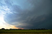
Here's a slightly zoomed-in view. Photo by Chris Kridler, SkyDiary.com, ChrisKridler.com
Around Union City, I stopped for a quick photo - the tornado is barely visible in the haze. Photo by Chris Kridler, SkyDiary.com, ChrisKridler.com
Cropped and contrast-enhanced: There's a big tornado in there. As the storm approached Route 81 a few miles to my north, several storm chasers were nearly trapped by the rapidly expanding and shifting tornado. As I write this, it is unclear exactly where the three storm chasers who died were. Photo by Chris Kridler, SkyDiary.com, ChrisKridler.com
I drove east of Union City on a gravel road, seeing the storm expand over my shoulder. I finally felt comfortable enough to stop and take a photo but was frustrated I couldn't see the tornado in all the dusty inflow and rain. At this time, it was huge - practically that whole dark area. Photo by Chris Kridler, SkyDiary.com, ChrisKridler.com
Here, just south of State Highway 152, I look north toward the storm and tornado. At this time, the tornado was on I-40. Photo by Chris Kridler, SkyDiary.com, ChrisKridler.com
I considered my options and briefly went north, then east. Traffic was not heavy here. Once I hit the road again with the idea of maneuvering south and west to get ahead of the storm, a conventional repositioning tactic, I got stuck in a southbound traffic jam near Mustang. Limited roads north of the Canadian River gave me no way out. Photo by Chris Kridler, SkyDiary.com, ChrisKridler.com
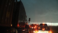
The nightmare on Route 4 south unfolded. Oklahoma City TV station KFOR had told people to flee their homes. Result: an disaster-movie-style traffic jam as the storm shifted southeast with new tornado-warned areas of rotation. I was never more frightened on a chase as I was sitting in traffic. Hundreds could have died. Fortunately, a new tornado did not materialize at my location. Here, people fill all lanes (including northbound and shoulders) going south in an attempt to get away as the couplet passes overhead. Photo by Chris Kridler, SkyDiary.com, ChrisKridler.com