May 18, 2010: I started the day in Lubbock, Texas. It seemed to me the best conjunction of moisture, wind profiles and other factors pointed to the Oklahoma-Texas border in the northwest Texas panhandle. As I drove into Amarillo, I heard the old crew (Dave Lewison, Scott McPartland, Mark Robinson and friends) on the radio and hooked up with them and with Bill Hark in Dumas. We went to Dalhart to wait for a likely storm, and a blip on radar near Dumas quickly became an amazing, isolated supercell. Our crew split up, but I met them later. I say I saw "at least one" tornado today because one was obvious. Another sure looked like one, but I'm waiting for confirmation. And who knows how many I filmed in the dense hail/rain core without knowing it. There were a lot of "scud bombs" hanging from the storm that probably prompted reports, too. Here are the photos.
Share
Click on the thumbnails to see a larger image, or view these photos as a gallery. From the gallery pages, click the "up" arrow to return to this index.
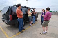
Dave puts fries on his burger in Dumas. Whatever works.
Bill Hark, right, flew in from Virginia for the chase. We waited around Dalhart, Texas, until the first blip went up on radar.
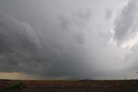
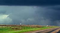
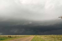
The radar "blip" rapidly became a severe storm near Dumas.
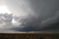
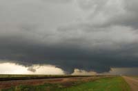
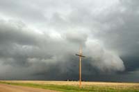
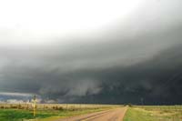
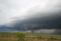
I split from our group and went a little south because I wanted to get out of the precipitation. I got a clear view of the formation of the rotating wall cloud.
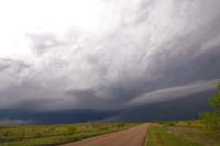
The wall cloud became more defined.
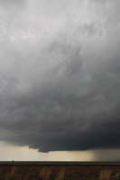
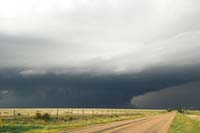
Rapid motion could be seen in the maturing wall cloud.
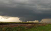
The wall cloud shows rotation as it grows. Note the feature in the back.
At this point, the wall cloud may have been on the ground - that is, a tornado! My video shows strong rotation, and a series of video grabs shows what looks like dust on the ground. I can't confirm it was, however, because I wasn't close enough.
Judge for yourself ...
If it wasn't a tornado, it should have been.
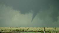
Here's a view of the wall cloud/possible tornado taken with a digital camera.
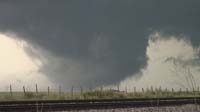
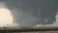
Then the storm formed an unquestionable tornado.
It appeared to persist as a cone, but rain hid it well. (Contrast enhanced.)
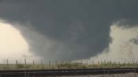
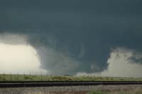
Here's another contrast-enhanced video grab.
This became a rapidly rotating wall cloud, but it did not produce a tornado that I saw.
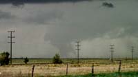
I took a southern route to avoid the baseball-or-larger hail and got this view. Note the inflow tail.
A dense rain and hail core hid at least some of the reported tornadoes. Not sure if there's one in there...
The base certainly was toothy.
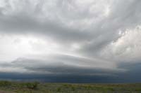
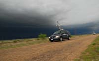
Here's another look at the storm, which by now was west of Stinnett. There was a lot of motion and some rotation. That's a Vortex 2 instrument pack by the side of the road.
The laminar appearance made me wonder if the storm would go linear.
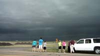
In Stinnett, these kids posed for a photo (taken by someone in their vehicle) in front of the storm - which at the time had a large tornado reported in it - as the sirens blared.
A Vortex 2 probe zooms down a ranch road near Stinnett, where a large tornado was reported in the precip core as the sirens blared.
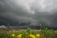
Rising scud clouds and rotation continued to characterize the storm, which had lots of hanging scud that would be easy to misinterpret as tornadoes.
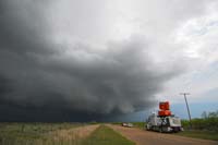
The Vortex 2 phased array radar checks out the storm just east of Stinnett.
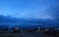
An artsy look.
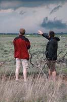
Mark and Brad scan the storm outside Stinnett at dusk as we let it slip by.