:: home
:: books
:: gallery
:: data
:: blog
:: kids
:: shop
:: bio
:: help
:: contact
:: ChrisKridler.com


Words/images COPYRIGHT © 2021 by Chris Kridler. All rights reserved. Do not use Sky Diary photos on other Web sites. Personal use as computer wallpaper is permitted, but do not distribute photos. Write for information about purchasing video, photographs or articles. | Frequently asked questions
|
|
storm gallery: May 15, 2009
May 15, 2009: It seemed clear that there would be storms today, and that they would likely develop rapidly into a squall line once they fired. I thought about a couple of possible targets - the Texas panhandle, where storms could be more isolated on the dryline, and the Kansas-Oklahoma border near Alva, which was not an unreasonable drive (always a consideration) and also had enough upper-level support and huge convective potential to make me think something interesting might happen there. Eventually, there was a tornado reported in the panhandle, but I had cast my luck with northern Oklahoma. I've added a few pictures from May 16 - my drive home - at the end of this account.
Share
Click on the thumbnails to see a larger image, or view these photos as a gallery. From the gallery pages, click the "up" arrow to return to this index.
 |
 |
 |
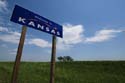
| I went into Kansas at Hardtner, north of Alva, then went back just below the border to keep an eye on the sky. |
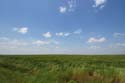
Small cumulus clouds were developing on the front, oriented southwest to northeast. |
With the exception of one Texas storm, the others started in east-central Kansas and zippered southwest. I went west of Medicine Lodge to have a look. |
 |
 |
 |
| There were a couple of reports of funnel clouds farther north. I was hoping my part of the line would have more isolated development. |
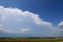
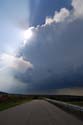
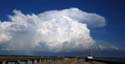
"My" cells took a while to get going, but this was a pretty sight. |
Another view as the growing cluster neared... |
 |
 |
 |
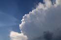
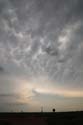
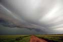
| Beams of light and pretty convection. |
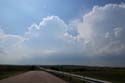
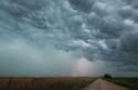
I wasn't seeing much in the way of isolated storms on radar, and one promising one was too far north, so I dropped south to pursue a strong line segment. |
Quarter-size hail or bigger was reported in the storms. |
 |
 |
 |
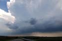
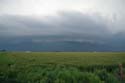
| Nice mammatus were forming in the anvil. |
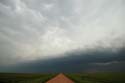
The line became more laminar as I headed east on Oklahoma Route 11. |
Here's a broader view of the layered gust front. |
 |
 |
 |
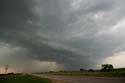
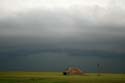
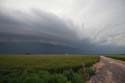
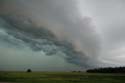
| Wheat and storm. It wasn't easy to find parking spaces to take pictures, as at least some of the Vortex 2 research caravan was also on this road. |
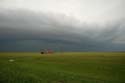
Another angle on the dramatic gust front. |
Sweeping in. |
 |
 |
 |
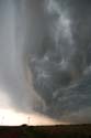
| Letting the line begin to overtake me, I saw the "whale's mouth." |
Looking to the north. |
A short time exposure blurs the clouds and reveals a quick lightning bolt in the rain. I let the line overtake me at I-35, then drove through it again to start my drive east and home. |
 |
 |
 |
| May 16: On my way home, I saw a tiny funnel out of a storm in Mississippi. I've enhanced the contrast. It wasn't tornadic - just one of those things. |
A beautiful storm May 16, as seen from Mobile, Alabama, welcomed me back to the southeast. |
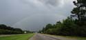
As shot through my windshield May 16, a rainbow. I returned to Florida for what I hope will be a summer of good lightning storms. |
2009 reports and photos
go to the main gallery page | go to storm chasers
go to reports from 2008, 2007, 2006, 2005, 2004, 2003, 2002, 2001, 2000, 1999, 1998, 1997
|
