:: home
:: books
:: gallery
:: data
:: blog
:: kids
:: shop
:: bio
:: help
:: contact
:: ChrisKridler.com


Words/images COPYRIGHT © 2021 by Chris Kridler. All rights reserved. Do not use Sky Diary photos on other Web sites. Personal use as computer wallpaper is permitted, but do not distribute photos. Write for information about purchasing video, photographs or articles. | Frequently asked questions
|
|
storm gallery: May 13, 2009
May 13, 2009: I started the day in Chickasha, Oklahoma, and at first targeted northern Oklahoma. I talked the day over with Jim Leonard (thanks, Jim!), who suggested Kansas had better potential for tornadoes - though the veered surface winds made the profile less than ideal, as did the likely formation of a line of storms on the cold front. I thought Kansas would fire earlier, too, and the RUC model moved the convective potential bullseye into southeast Kansas, so I headed toward Independence, Kansas. Then the first "bomb" went off on the front northwest of me, so I tried to get in position as the whole line lit up.
Share
Click on the thumbnails to see a larger image, or view these photos as a gallery. From the gallery pages, click the "up" arrow to return to this index.
 |
 |
 |
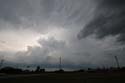
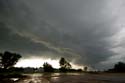
| I went into eastern Kansas and got close to the line as storms fired off the cold front. |
Cloud features under the line of storms made me pay attention. |
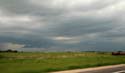
I decided to let the squall line pass me at Iola, in hopes of sampling hail from under a shelter. |
 |
 |
 |
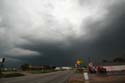
| But the rule is - when I have shelter, the hail doesn't come. Just pea-size stones fell as the squall line passed. |
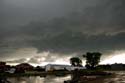
Instead of watching this pretty thing, I probably should have been driving east and getting ahead of the storm... |
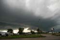
... because a little east of Iola, this part of the storm (or the more intense part north of my location) developed a couplet and produced at least one tornado. It was warned for a while. |
 |
 |
|
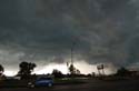
| There was some nice green color in the line, probably from the hail to my north. |
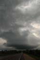
So I came away with very little today. Here's a cute little updraft, the dregs of the line, at Humboldt. |
2009 reports and photos
go to the main gallery page | go to storm chasers
go to reports from 2008, 2007, 2006, 2005, 2004, 2003, 2002, 2001, 2000, 1999, 1998, 1997
|
