:: home
:: books
:: gallery
:: data
:: blog
:: kids
:: shop
:: bio
:: help
:: contact
:: ChrisKridler.com


Words/images COPYRIGHT © 2021 by Chris Kridler. All rights reserved. Do not use Sky Diary photos on other Web sites. Personal use as computer wallpaper is permitted, but do not distribute photos. Write for information about purchasing video, photographs or articles. | Frequently asked questions
|
|
storm gallery: May 8, 2009
May 8, 2009: Most of today was frustrating. I began the day in Bartlesville, Oklahoma, and decided the front and the monster convective potential suggested southeast Oklahoma might be the place to catch storms today, or somewhere along the Red River between Oklahoma and Texas. I made the long drive down to Durant, Oklahoma, on the border, had a late lunch and pondered my options. I decided I needed to get a little west, closer to the front, and also wanted to keep an eye on a line of cumulus clouds developing in clearer air in Texas. Those started to pop, and I made the decision to go south. A while later, I decided I didn't want to bother with those south-moving hailers, especially because it might take a while to catch them - yet a tornado was reported from one of them in Early, later. Meanwhile, a line of storms was going up to my west, so I checked them out. The result was beautiful.
Share
Click on the thumbnails to see a larger image, or view these photos as a gallery. From the gallery pages, click the "up" arrow to return to this index.
 |
 |
 |
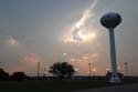
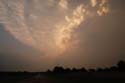
| A line of cells west of Bridgeport, for the most part, didn't become very strong. |
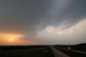
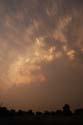
As seen from Route 287 near Bowie, one of the cells (left) shrunk and collided with a booming cell on the Red River north of Bowie (right). |
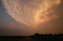
Already strong, the storm north of Bowie was about to gain strength. |
 |
 |
 |
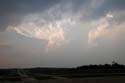
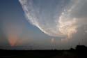
| This storm took over its part of north Texas. |
After the storm absorbed the dying cell to its south, it showed a noticeable strengthening on radar. |
Radar suggested that, at least briefly, the storm north of Bowie had very large hail. |
 |
 |
 |
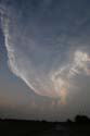
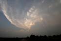
| The severe-warned storm acquired lovely color after sunset. |
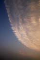
Check out the hard convection. |
The circular anvil began to light up, too. |
 |
 |
 |
| The anvil and towers (bottom) feeding into the storm. |
Wow ... |
Storm on fire! |
 |
 |
 |
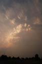
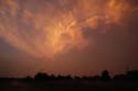
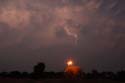
| Intense color after sunset. |
Now, it's coral ... |
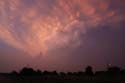
In twilight, the storm turned pink. |
 |
 |
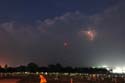 |
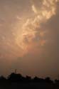
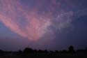
| The storm faded to blue. |
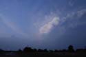
The cell sparked as darkness fell. |
The cell was rejuvenated by new towers after dark and later had a tornado warning. |
2009 reports and photos
go to the main gallery page | go to storm chasers
go to reports from 2008, 2007, 2006, 2005, 2004, 2003, 2002, 2001, 2000, 1999, 1998, 1997
|
