:: home
:: books
:: gallery
:: data
:: blog
:: kids
:: shop
:: bio
:: help
:: contact
:: ChrisKridler.com


Words/images COPYRIGHT © 2021 by Chris Kridler. All rights reserved. Do not use Sky Diary photos on other Web sites. Personal use as computer wallpaper is permitted, but do not distribute photos. Write for information about purchasing video, photographs or articles. | Frequently asked questions
|
|
storm gallery: May 8, 2008
May 8, 2008: We knew storms would fire early in Western Kansas today - if they fired - but we didn't know how early. The first tornado reports on one little cell were about 2:30 p.m. Central time, beautiful landspouts we missed. But we caught up to the storm when it really started cranking. I chased with Dave Lewison, Scott McPartland, Mark Robinson and his cameraman Dave, along with a Pioneer Productions crew, though we were separated early in the chase. I also got a much-needed radar update from Bill Hark when I was trying to avoid the hail core at Jetmore.
Click on the thumbnails to see a larger image, or view these photos as a gallery. From the gallery pages, click the "up" arrow to return to this index.
 |
 |
 |
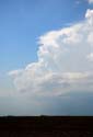
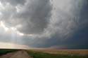
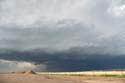
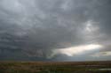
| On May 8, 2008, this storm northwest of Garden City, Kansas, had already produced multiple landspouts before we got on it. It had vigorous convection. |
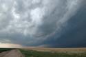
The cell got a radar-based tornado warning on it, and the base assumed an interesting near-bowl shape. |
The inflow became more pronounced as the storm approached my position on Route 23. |
 |
 |
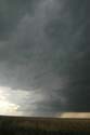 |
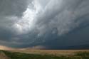
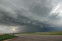
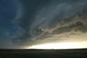
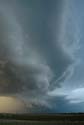
| The cell showed signs of rotation and insanely strong inflow. |
The storm was beautiful as it moved southeast. |
A look at the southern end of the storm. |
 |
 |
 |
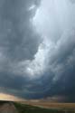
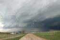
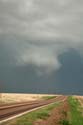
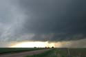
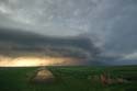
| The mesocyclone showed rapid rotation and I experienced intense inflow winds. I saw a rear-flank downdraft and as the hail wrapped around, I dropped a bit south to avoid it and got this view. |
Here's another view as the dangerous rotating storm sweeps over this farm. |
I let the business end of the storm slide east of me so I wouldn't have to tangle with the hail core. Power poles were snapped near Jetmore, probably in the inflow. |
 |
 |
 |
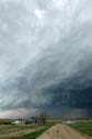
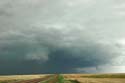
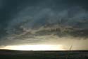
| This is a view of the storm looking northeast. |
Check out the green color, suggestive of lots of hail. A radar update from Bill Hark helped me avoid it. |
The storm had a lot of suggestive lowerings, many of which weren't in the right place to produce a tornado. |
 |
 |
 |
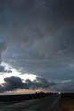
| Another view as the storm evolved and another one came in from the northwest. |
Looking west at approaching storms. |
The gnarly outflow-dominant storm approaches from the west. |
 |
 |
 |
| The expanding shelf cloud was screaming southeast. |
The lowering sun gave the shelf cloud an orange underglow. |
The rapidly moving shelf cloud/gust front was gorgeous but hard to stay in front of. |
 |
 |
 |
| I let the storm overtake me in Bucklin, Kansas. This is a video grab. |
Mammatus were seen in the storm's wake. |
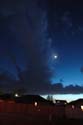
Over Dodge City, the moon peeked out from behind lingering clouds. |
2008 reports and photos
go to the main gallery page | go to storm chasers
go to reports from 2007, 2006, 2005, 2004, 2003, 2002, 2001, 2000, 1999, 1998, 1997
|
